The River Siang descends from the Tibetan Plateau where it is known as the Yarlung Tsangpo and makes its way through the steep gorges of the lower Himalayas in Arunachal Pradesh before hitting the plains at Pasighat, where after it meets with the Lohit, Dibang, Subansiri, Kameng and a host of other rivers that originate in India it becomes the mighty Brahmaputra.
 I recently fulfilled a long standing desire of mine to go up the Siang valley up to the China border to imbibe first hand the legendary beauty of this river about which I had read on the internet. Not only does the river wend its way through spectacularly forested hills but there are many places along it, where it rushes over rapids in a roar of white foam. This is what has made it one of the world's most sought after white water rafting destinations.
 The lower Himalayas are not very high and the highest point on our route was the town of Migging at a height of 1000 meters above sea level. Only near this place are there a few snow capped mountains visible. This is a picturesque place with scenically situated villages on hill tops and high valleys in a very sparsely populated landscape that is heavy with vegetation.
 The villagers across the river Siang, from the side on which the road is, mostly have to use suspension foot bridges made of steel wires and wooden planks to cross the river and reach the road. Since the span has to be small, the bridges are constructed near the river and so the people have a steep climb to the road above. These bridges sway tantalisingly when one walks on them.
 Initially there was only one suspension bridge across the Siang at a place called Dite Dime about 108 kilometers up the river from Pasighat on which cars and trucks could ply. Then a two lane concrete road bridge was constructed in 2009 at Pasighat. Now, on the day we arrived at Yingkiong, the headquarters of the Upper Siang district, at a distance of 130 kms from Pasighat, a big two lane suspension bridge was opened at this town named the Byorung bridge. Earlier there was only a suspension footbridge here which can be seen at the side.

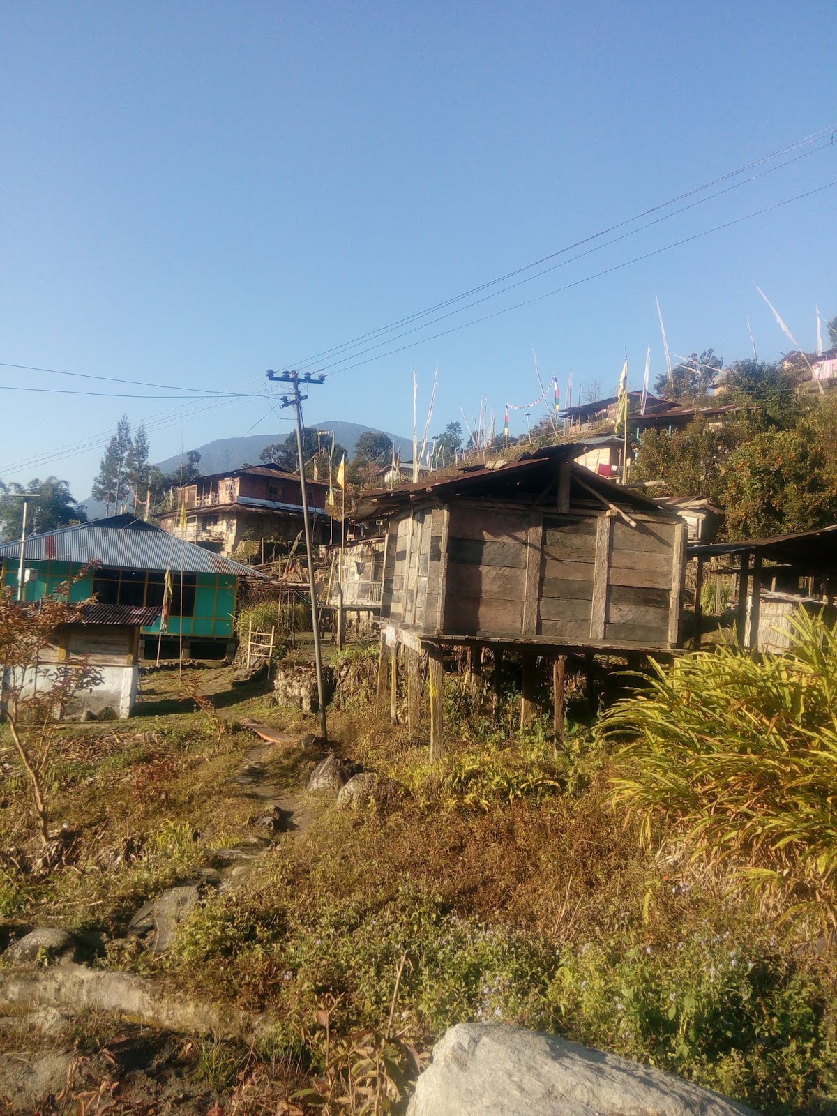
The Siang valley is mostly populated by the Adi tribes people who have their own nature worshiping religion known as Donyi Polo which are the Adi names for the sun and the moon. In the upper reaches near the China border there are Pemba tribes who are Buddhists. The people are mostly farmers and hunters. They cultivate rice in terraced fields and live in bamboo and thatch houses on stilts. The thatch is skillfully made of Tok leaves that are weather resistant. These houses stay warm during winter and cool during summer.
 They rear pigs in picturesque sties that are also built on stilts and inside their homes there is a hearth that is used for both cooking and warmth. The hearth has two hanging shelves over it on which food and firewood are kept warm. The floors and walls are made of bamboo or wooden planks.
 The last administrative town up the Siang valley is Tuting which is 160 kms from Yingkiong. It has an airport for the use of the army which has an extensive setup here. It also has an inspection bungalow where visitors can stay after getting permission from the administrative officer. The town is situated on the banks of the Siang but being hilly it has many levels. The last village on the China border is Gelling which is about 30 Kms from Tuting. On the way there is a fine Buddhist temple in village Bone as these areas are inhabited by the Pemba tribes people who are Buddhists.
 Gelling is situated on a hill top high above the Siang and just below the spur of the hill that marks the border between China and India. A few kilometers upstream of Gelling the Siang takes a bend and enters India. Traditionally the houses were built of bamboo and thatch on stilts but like elsewhere in the Siang valley modern construction has made its presence felt in this village also.
 The trip up the Siang valley was not just one of enjoying its wild beauty but also about understanding the water flow dynamics of the Brahmaputra River. The Brahmaputra river in recent years has witnessed a peculiar anomaly. While there are huge floods during the monsoons, during the rest of the year the flow becomes limited. I wanted to investigate this. I also wanted to get to the bottom of the claim made by the Indian Government's Water Resource Managers that the damming of the Yarlung Tsangpo by China in Tibet would drastically affect the flows of the Brahmaputra. I had read a research paper once that had on the basis of analysis of satellite imagery concluded that the Yarlung Tsangpo contributed only about 5 per cent of the total annual flow of the Brahmaputra. The trip up the Siang confirmed this. The river is hardly about 150 meters wide and very shallow below Gelling village with a miniscule flow as compared to the flow in the Brahmaputra plains.
Surprisingly, there is no measurement of the flow of the Siang at Gelling where it enters India even though there are flow measurement stations at Tuting, Yingkiang and Pasighat further downstream. Even so the flow measurements from these stations, which are classified data and so are not available to the general public, must clearly be showing that the flow of the Yarlung Tsangpo into India is miniscule compared to that of the Siang in India itself and even less if compared to that of the whole Brahmaputra basin.
The most important data from the measurement of the flow of all the rivers that are tributaries of the Brahamputra is that regarding their contribution to the flood flow of the Brahmaputra during the monsoons which has such a devastating effect annually. Given the steep slopes of the lower Himalayas and the huge deforestation that has taken place, heavy rains in the hilly catchments of the tributaries of the Brahmaputra are the main cause of floods. Thus, it is imperative that both natural and artificial recharge is drastically increased in the Arunachal hills for any worthwhile flood control to be possible. The challenge to implementing artificial recharge measures is the steepness of the slopes and the very sparse population in the area. Nevertheless, thought must be applied and solutions found for this problem. The higher costs involved in this will be compensated many times by the prevention of losses due to floods. Moreover, artificial recharge will ensure that there is a better flow during the lean season and so improve the possibilities of navigation and irrigation in the Brahmaputra valley much more than building dams and dredging will ever do.
The other side of the coin is the diminished lean season flow in the rivers. Whereas the Siang has a good lean season flow due to the snow melt in the Tibetan plateau and upper Himalayas, the other rivers have very low flows. Due to the huge monsoon flows these rivers have very wide beds stretching to a few kilometers in width but just after that they dry up substantially. The Lohit River has the longest road bridge across it at Sadiya measuring 9 kilometers in length while the Dibang River has the third longest at 6.2 kilometers. The Bogibeel bridge across the Brahmaputra has the second longest bridge at 6.4 kilometers. However, when we crossed these bridges on our return from the Siang valley we found the river beds to be mostly dry and in some places covered with vegetation with the water flowing in a small stream.
 But the Government Water Resource Managers have turned a blind eye to this and are instead bent on building dams on these rivers ostensibly to control floods but actually to make merry from their construction. The pristine beauty of the Siang valley has no value for these and the profit seeking dam building corporations.
Arunachal Pradesh is inhabited by tribes and and strict rules that prevent people from outside the state from settling or doing business there have kept the place comparatively safe from the depredations of greed based modern development and trade. Those going in for work or tourism have to obtain an inner line permit which is given for only a fortnight and has to be renewed after that. Even then dam building has made its mark in the Subansiri river valley and may some day lay the Siang valley to waste due to the local political leadership being inclined towards it. An interesting thing that I noted was that Hindi has become the lingua franca of the state. Everywhere right up to the China border people speak Hindi and some of them speak very chaste Hindi with good diction and pronunciation. The day we reached Yingkiong there was a big public meeting of the Chief Minister and he was speaking in Hindi because his own tribal language would not be comprehended by the Adi tribes people in the audience!!!
Finally a word about the roads. While the road to Yingkiong is fairly good apart from the stretches where construction work is going on, thereafter, up to Tuting the road is atrocious. We could drive at a an average speed of 15 kilometers and hour and it took us 9 hours to cover the distance. This is indeed a pity because this road is strategically very important and there is heavy army traffic on it most of the time and also because a good road combined with good tourism infrastructure can really open up this beautiful valley which is now visited only by river rafting enthusiasts. However, it is necessary to build these roads so as to cling to the contours as much as possible because the steep slopes get destabilised by the road cutting. While going up on the first day our path up the left bank of the river was blocked by a section where a landslide had taken place and taken the road with it. We had to turn back and return to Pasighat to cross the bridge there and go up the right bank instead. On our return journey also we encountered a land slide but that held us up for only an hour or so. The land slides during the monsoons are even more severe and frequent.
Even though the road situation is poor, there is fairly good mobile connectivity in the towns and also along the route. The road condition delayed my schedule and so at Tuting I had to reschedule my return flight from Guwahati by a day. As there was good mobile connectivity in the town, I could call up the airline and reschedule my flight.
All in all the trip up the Siang turned out to be truly one off the beaten track. The author James Hilton in his novel "Lost Horizon" has written about a mystical valley called Shangri-La where people live harmoniously. The Siang valley comes close to that utopian ideal and the trip was for me the experience of a lifetime.


The Siang valley is mostly populated by the Adi tribes people who have their own nature worshiping religion known as Donyi Polo which are the Adi names for the sun and the moon. In the upper reaches near the China border there are Pemba tribes who are Buddhists. The people are mostly farmers and hunters. They cultivate rice in terraced fields and live in bamboo and thatch houses on stilts. The thatch is skillfully made of Tok leaves that are weather resistant. These houses stay warm during winter and cool during summer.


Surprisingly, there is no measurement of the flow of the Siang at Gelling where it enters India even though there are flow measurement stations at Tuting, Yingkiang and Pasighat further downstream. Even so the flow measurements from these stations, which are classified data and so are not available to the general public, must clearly be showing that the flow of the Yarlung Tsangpo into India is miniscule compared to that of the Siang in India itself and even less if compared to that of the whole Brahmaputra basin.
The most important data from the measurement of the flow of all the rivers that are tributaries of the Brahamputra is that regarding their contribution to the flood flow of the Brahmaputra during the monsoons which has such a devastating effect annually. Given the steep slopes of the lower Himalayas and the huge deforestation that has taken place, heavy rains in the hilly catchments of the tributaries of the Brahmaputra are the main cause of floods. Thus, it is imperative that both natural and artificial recharge is drastically increased in the Arunachal hills for any worthwhile flood control to be possible. The challenge to implementing artificial recharge measures is the steepness of the slopes and the very sparse population in the area. Nevertheless, thought must be applied and solutions found for this problem. The higher costs involved in this will be compensated many times by the prevention of losses due to floods. Moreover, artificial recharge will ensure that there is a better flow during the lean season and so improve the possibilities of navigation and irrigation in the Brahmaputra valley much more than building dams and dredging will ever do.
The other side of the coin is the diminished lean season flow in the rivers. Whereas the Siang has a good lean season flow due to the snow melt in the Tibetan plateau and upper Himalayas, the other rivers have very low flows. Due to the huge monsoon flows these rivers have very wide beds stretching to a few kilometers in width but just after that they dry up substantially. The Lohit River has the longest road bridge across it at Sadiya measuring 9 kilometers in length while the Dibang River has the third longest at 6.2 kilometers. The Bogibeel bridge across the Brahmaputra has the second longest bridge at 6.4 kilometers. However, when we crossed these bridges on our return from the Siang valley we found the river beds to be mostly dry and in some places covered with vegetation with the water flowing in a small stream.

Arunachal Pradesh is inhabited by tribes and and strict rules that prevent people from outside the state from settling or doing business there have kept the place comparatively safe from the depredations of greed based modern development and trade. Those going in for work or tourism have to obtain an inner line permit which is given for only a fortnight and has to be renewed after that. Even then dam building has made its mark in the Subansiri river valley and may some day lay the Siang valley to waste due to the local political leadership being inclined towards it. An interesting thing that I noted was that Hindi has become the lingua franca of the state. Everywhere right up to the China border people speak Hindi and some of them speak very chaste Hindi with good diction and pronunciation. The day we reached Yingkiong there was a big public meeting of the Chief Minister and he was speaking in Hindi because his own tribal language would not be comprehended by the Adi tribes people in the audience!!!
Finally a word about the roads. While the road to Yingkiong is fairly good apart from the stretches where construction work is going on, thereafter, up to Tuting the road is atrocious. We could drive at a an average speed of 15 kilometers and hour and it took us 9 hours to cover the distance. This is indeed a pity because this road is strategically very important and there is heavy army traffic on it most of the time and also because a good road combined with good tourism infrastructure can really open up this beautiful valley which is now visited only by river rafting enthusiasts. However, it is necessary to build these roads so as to cling to the contours as much as possible because the steep slopes get destabilised by the road cutting. While going up on the first day our path up the left bank of the river was blocked by a section where a landslide had taken place and taken the road with it. We had to turn back and return to Pasighat to cross the bridge there and go up the right bank instead. On our return journey also we encountered a land slide but that held us up for only an hour or so. The land slides during the monsoons are even more severe and frequent.
Even though the road situation is poor, there is fairly good mobile connectivity in the towns and also along the route. The road condition delayed my schedule and so at Tuting I had to reschedule my return flight from Guwahati by a day. As there was good mobile connectivity in the town, I could call up the airline and reschedule my flight.
All in all the trip up the Siang turned out to be truly one off the beaten track. The author James Hilton in his novel "Lost Horizon" has written about a mystical valley called Shangri-La where people live harmoniously. The Siang valley comes close to that utopian ideal and the trip was for me the experience of a lifetime.

6 comments:
Great piece Rahul - enjoyed reading it. I can hear both the traveler and the engineer in you. My work used to take me to the North East and I always found it fascinating. Your post brings it out vividly.
- Atish
Beautiful writing Rahul. Very vivid.
We are not adivasi please mind your tongue we are tribal people from arunachal thats it n we r literate enough to run this country so next time please mind your tongue n next time you post something about us the arunachales or any north eastern state just write tribal not adivassis as if we are junglees or remote people.
Looks as if you have not read the post because I have throughout referred to the indigenous people of Arunachal as tribes people!! And definitely they can run the whole country much better than it is being run at present!!!
Adivasi is a Hindi word whereas Tribal is an English word. No difference. Further, the words refer to indigenous people.
In the Northeast there is a special situation that the tribes people from Jharkhand who have been settled in the tea gardens are called Adivasis and the local tribes people of the North East differentiate themselves from the tea tribes as they are known who are listed as Other Backward Classes. However, the Central Government has now accepted a long standing demand of the tea tribes to be given Scheduled Caste Status along with 7 other tribes like the Koch Rajbonshis.
Post a Comment